

An HDD guidance system (horizontal directional drilling) is the set of downhole sensors, data paths and surface equipment used to place a pilot bore where the design says it belongs. Choosing between walkover, downhole magnetic and gyro steering is an accuracy-budget decision. Steering, surveying and tracking are often delivered by different tools, and their errors accumulate along the drilled length.
Scope: this comparison applies where tolerance can be stated as a position band over a given drilled length. This guide separates those functions, compares each family on depth, interference and accuracy, translates published gyro figures into meters of position error, and closes with the verification mistakes that hide inside an as-built. Guidance choice and the tolerances to be held are inputs to project-specific design and must be confirmed by a competent engineer for the actual crossing.
Why an HDD Guidance System Is Not Just a Locator
A locator answers where the drill head is right now; a guidance system answers what that position means for the bore path and permit tolerance. Guidance-accuracy work published by the NASTT South Central Chapter, a regional branch of the trenchless technology industry association, separates three functions.
| Function | Sensor and hardware | What it outputs | Typical limitation |
|---|---|---|---|
| Steering | Accelerometer in the steering tool | Inclination and roll angle, used to orient an offset bit, sub or motor | Describes the head only; steering error survives the whole bore |
| Surveying | Downhole magnetic or gyro sensors | Azimuth relative to the earth’s poles and pitch relative to gravity, with measured depth | Position is only as good as the tie point and survey interval |
| Tracking | Surface or adjacent-conduit source: cable, beacon tracker or microcoil | A periodically energized signal read downhole, adding tie points | Needs access, power and crew discipline |
A walkover locator covers steering and, if a surveyor shoots the position, a weak form of tracking. That gap is where as-built disputes begin: a bore can close within tolerance at the exit and still sit outside the corridor in the middle.
How Walkover Guidance Works, Where It Fits, and Where It Fails
In a walkover system a hand-held receiver is carried above a sonde housed in or behind the drill head. It reads the sonde’s electromagnetic field and resolves depth, pitch, roll and heading plus a signal strength that shows whether it is directly over the head. The driller steers from those readings, one rod at a time.
Where it fits:
- Shallow utility bores where cover is modest, the alignment short and the tolerance band generous.
- Short, simple crossings with a walkable centerline and no obstruction over the bore.
- Small rigs and single-pass installations such as fiber, water, gas and power ducts.
In our equipment reviews, walkover is the fastest system to set up on a utility bore: two people, a receiver and a sonde, and no cable.
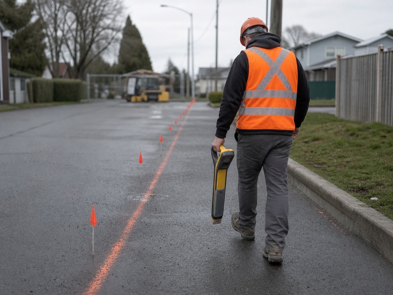
The limits are specific, and the NASTT South Central Chapter guidance-accuracy report of 2018 sets them out:
- Depth. Electromagnetic fields have a depth limit, and the practical depth range is usually significantly less than the published figure.
- Signal expansion. As depth increases the emitted field expands, so closure values become increasingly subject to operator interpretation.
- Passive interference. Reinforcing steel, rebar, sheet piling and buried metal degrade the field, and active utilities add signal.
- As-built weakness. A hand-held locator measures depth and heading, so it produces a weaker as-built unless a surveyor independently shoots the position.
Our field teams record the closure reading twice, from opposite directions, whenever a walkover bore approaches the practical depth edge; when the two disagree the difference is interpretation, not measurement. Where the tolerance is tighter than walkover can defend, an alternative method such as trenchless technologies or microtunneling construction can be more commercial.
Downhole and Wireline Magnetic Guidance: One Tie Point, Then Many
A downhole survey is computed from one tie point at entry, from sensors that read azimuth and pitch while measured depth is tracked at the rig.
A tracking source is energized periodically and read by the same magnetometers: a wire run in a known pattern, a beacon tracker or a microcoil in an adjacent conduit, and every energized shot adds a tie point. Tie points therefore matter more than the sensor on a long bore, because a survey from the entry point alone trusts one reference for the crossing.
Wireline describes only a power and data transmission method and can be used on rigs of any size; it is not a rig or depth class. Wireline steering therefore says nothing about surveyable depth. The correct term for a system that works without surface access is downhole, and a downhole system has no inherent depth limitation.
Tracking methods are not equivalent either. A DC loop (a wire laid in a rectangle and energised with direct current) gives a standalone survey against a known field. An AC system (alternating current on one side of the wire) depends more on operator input and widens the error window. Published sources disagree, so the trade-off depends on the crossing and crew.

When Is a Gyro Steering Tool the Right Choice?
Gyro systems are north-seeking: a continuously driven gyroscope holds a north reference with no surface access. A gyro therefore works where magnetics fails – inside or beside steel casing, near shore piles, under ship traffic and next to active utilities – and on deep, long or water crossings. A gyro is the HDD guidance system of choice for casing work because it is unaffected by the steel it runs beside.
On large force-main and casing crossings, operators commonly log the installed steel casing with a gyro steering tool, because a magnetic tool would be disturbed by the casing. Inclination and azimuth are recorded every few metres as the pipe advances.
The limits are practical rather than theoretical:
- Drift. North reference has to be maintained, and most gyros have no secondary measurement system, relying on a geometric calculation at each survey shot.
- Power dependence. Gyros depend on an electrical supply, which adds a failure mode on a remote spread.
- Shock and vibration. They are subject to mechanical damage, and several tools may be needed for a rock job.
- Physical size. A gyro is housed in a steel sub about 8.5 ft long, weighing up to 1,200 lb. A magnetic tool measures roughly 3 ft, 1.75 in outside diameter and about 35 lb, and ships easily.
In our toolroom experience the handling cost, not the survey, decides gyro economics: transport, rig-up time and a spare tool belong in the estimate.
| Attribute | Magnetic steering tool | Gyro steering tool |
|---|---|---|
| Typical housing length | About 3 ft | About 8.5 ft steel sub |
| Typical weight | About 35 lb | Up to 1,200 lb |
| Magnetic interference | Disturbed by casing, steel piles and live utilities | Unaffected by casing; used to log installed steel casing |
| Power and data | Sonde or cable powered from the rig | Needs an electrical supply and a maintained north reference |
| Shock and vibration | Tolerant of routine rod handling | Sensitive to mechanical damage |
| Known weak point | Magnetic bias near steel and live conductors | Drift over time, with no secondary measurement on most tools |
| Logistics | Shipped or flown easily | Heavy, needs planned transport and a standby tool |
The Accuracy Budget: How Survey Error Grows on a Long Crossing
Most borehole surveying uncertainty comes from systematic errors in the system: small inclination, azimuth and depth errors accumulate into an ellipse of uncertainty that grows with length. A tool specification describes one shot; an as-built reflects every shot.
Published gyro accuracy is about 0.01-0.02 ° of inclination and 0.04-0.1 ° of azimuth, and one NASTT publication reports 0.04 ° and 0.02 °. A manufacturer states that 0.04 ° of azimuth corresponds to about 0.7 m of position error per 1,000 m drilled, and 0.01 ° of pitch to about 0.17 m per 1,000 m. Treat these as reported figures, not guaranteed field accuracy.
| Error component | Published accuracy | Approximate position error per 1,000 m drilled | Comment |
|---|---|---|---|
| Azimuth | 0.04 ° | About 0.7 m | Lateral error; the dominant term on long bores |
| Azimuth | 0.1 ° | About 1.7 m | Published relation scaled proportionally |
| Pitch | 0.01 ° | About 0.17 m | Vertical error from inclination |
| Inclination | 0.02 ° | About 0.35 m | 0.01 ° relation doubled |
The 0.1 ° and 0.02 ° rows are those relations scaled proportionally; error scales roughly linearly with length. These are vendor-published relations, not as-built guarantees.
On a real crossing a 1,000 m bore surveyed from the entry point alone carries tool, steering and depth error together, so the ellipse of uncertainty widens with every meter.
Add a tie point at mid-length and the error is no longer free to accumulate over the full bore; cut the survey interval from 30 m to 3 m and the same tool yields a tighter envelope. That is why the accuracy budget of an HDD guidance system is written as survey interval, plus tie points, plus tool.
Walkover vs Downhole vs Gyro: A System Comparison
Each HDD guidance system family fits a defined window of depth, interference and access. The comparison below is organized by what each family can and cannot do, and keeps a risk row. A misapplied system’s cost appears later as a claim or a re-drill.
| Comparison point | Walkover | Downhole or wireline magnetic | Gyro steering |
|---|---|---|---|
| Function supplied | Steering plus approximate tracking | Survey from a tie point plus added tracking tie points | Survey with no surface access required |
| Power and data path | Sonde in the head, radio or cable to a hand-held receiver | Cable or battery sonde; wireline steering is only a power and data path and suits any rig size | Self-contained downhole tool with its own electrical supply |
| Surface access needed | Yes: a walkable, unobstructed centerline | Often yes for tracking, though the survey itself does not depend on it | No: works under water, roads, structures and steel |
| Depth behaviour | Practical depth range usually well below the published figure; the signal field expands with depth | No inherent depth limitation; accuracy depends on tie points and survey interval | No inherent depth limitation from the north-seeking reference |
| Interference sensitivity | High: passive interference and active utilities degrade the field | Sensitive to magnetic interference from steel and live conductors | Low to magnetic interference; chosen where magnetics fails |
| Accuracy character | Depth, pitch, roll and heading at the head; systematic error grows along the bore | Azimuth and pitch referenced to tie points; tie points greatly increase accuracy | Vendor-published inclination about 0.01-0.02 ° and azimuth about 0.04-0.1 °, subject to drift |
| Typical application | Shallow utility bores and short, simple crossings | Long crossings with surface access and workable magnetics | Steel casing, high-interference, deep, long and water crossings |
| Risk if misapplied | As-built cannot be defended at depth; closure error becomes a claim | Hidden bias where casing or structures disturb the magnetics | Extra cost, slower rig-up and tool damage where magnetics would have been adequate |
Read the comparison table by column rather than by row. Walkover wins on setup time and loses on depth; magnetic guidance wins on surveyed cost per meter and loses near steel; a gyro wins where magnetics cannot work and loses on handling time and cost.
Selection depends on site conditions and project requirements, not on a general ranking. Every figure here is a planning input rather than a design limit: guidance choice and the tolerances to be held must be confirmed by a competent engineer for the actual crossing.
How Do Hybrid and Combined Surveys Improve Accuracy?
The highest accuracy comes from combining a precision survey with secondary tracking, as most large crossings do:
- A gyro survey through steel casing, then a magnetic tool beyond it where magnetics is clear.
- A downhole survey re-referenced by a DC loop, giving a standalone check against a known field.
- Walkover readings for the shallow entry section, then a magnetic survey once interference makes the hand-held receiver unreliable.
- A reduced survey interval through the section with the tightest clearances rather than one uniform interval.
Combining systems costs money and rig time, so the justification should be a clearance or permit requirement rather than habit; in the crossings we have supported, the trigger was a casing section or a live utility.
Verification Mistakes That Go Unnoticed
Three failures survive to the as-built, and none shows up on a daily report:
- A single tie point over a long bore. The survey looks internally consistent, but every reading depends on one reference at the entry point, so even a good downhole survey leaves position error free to accumulate along the drilled length.
- Treating walkover closure readings as precise at depth. The value comes from an expanding field and operator interpretation, making it a steering aid rather than a survey measurement.
- No independent as-built verification. Nobody re-surveys the installed pipe or compares final position against the permit tolerance, so any error is inherited by the next project. An independent pipeline inspection service closes that loop cheaply compared with a re-drill.
The remedy for mis-read surveys, optimistic as-builts and unverified tolerance claims is procedural: state the survey interval and tie points in the bore plan, record the HDD guidance system configuration actually used, and make somebody answer for the as-built signature.
Frequently Asked Questions About HDD Guidance Systems
What is an HDD guidance system?
An HDD guidance system combines downhole sensors, a data path and surface equipment to establish where the pilot bore actually is. Steering, surveying and tracking are three separate jobs, and a system that only steers or only tracks is not a complete survey.
Is a walkover locator the same as a guidance system?
A walkover locator steers and tracks a shallow bore, while a guidance system also delivers a survey. The receiver reads depth, pitch, roll and heading over a sonde, and the receiver position itself is only measured when a surveyor shoots it, which separates a steering aid from a defensible as-built.
How deep can walkover guidance go?
The practical depth range is usually significantly less than the published figure. Electromagnetic fields have a practical depth limit, and as depth increases the emitted field expands so depth and closure readings become a matter of interpretation.
When should a gyro steering tool be used instead of a magnetic tool?
When magnetic interference is high, when steel casing, shore piles or ship traffic disturb a magnetic survey, or when the crossing is deep, long or runs under water. A gyro needs no surface access and keeps a north reference from a continuously driven gyroscope.
What is the difference between wireline and downhole guidance?
Wireline steering describes only a power and data transmission method and can be used on rigs of any size. The correct term for a system that works without surface access is downhole, and a downhole system has no inherent depth limitation.
How accurate is HDD guidance over a long crossing?
Accuracy is a budget, not a single number. Systematic errors accumulate into an ellipse of uncertainty that grows with drilled length, so published gyro figures such as 0.04 deg of azimuth, about 0.7 m per 1,000 m, only hold when survey interval and tie points are managed.
Our 1.4 km river crossing has about 12 m of cover and passes under a live steel main – which guidance system can hold the permit tolerance?
A gyro survey through the steel section plus a reduced survey interval at the critical cover is the combination to price first, because tie points and survey interval decide the envelope rather than the tool alone. A 1,400 m run surveyed from the entry point alone accumulates tool, steering and depth error, so add a mid-length tie point and tighten the interval through the constrained section.
Key Takeaways
- Steering, surveying and tracking are separate jobs; choose a system that covers the ones your tolerance needs.
- Walkover is fast and inexpensive, but its practical depth range is usually well below the published figure and it needs a surveyor for a defensible as-built.
- Downhole magnetic guidance delivers a genuine survey from a tie point, and added tie points plus a tighter interval usually buy more accuracy than a costlier tool.
- A gyro is the answer where magnetics fails, at the cost of handling weight, power dependence and drift.
- Choose the HDD guidance system that matches site conditions and the tolerance to be held, and confirm the choice with a competent engineer for the actual crossing.
How JSW Supports HDD Guidance and Pipeline Projects
JSW executes trenchless crossings with its own crews and equipment. Our scope covers HDD crossing services and usługi w zakresie montażu rurociągów, and we plan guidance, survey interval and as-built verification as part of the bore design.
What distinguishes our support is integrated delivery. Bore planning fixes the survey interval and tie points before the rig moves, and process data stays auditable. Pricing separates known ground from allowance, and installation practice follows the references that govern HDD work, including ASCE Manual of Practice 108 and ASTM F1962. The tool is selected against the tolerance rather than the other way round.
- Integrated delivery: engineering, guidance planning, drilling, product pipe installation and site restoration under one contract.
- Auditable data: survey records, tie-point logs and survey intervals retained for as-built handover.
- Risk-explicit pricing: stated assumptions for ground conditions, crossing length and guidance method.
- Owned equipment: rigs, guidance tools and drilling fluid systems operated by our own crews.
Not sure which guidance system your crossing needs? Send your bore plan, target tolerance and geotechnical data for a free technical review. Our engineers respond with a scoped recommendation and budget range.












 English
  Arabic
  Russian
  Spanish
  French
  Vietnamese
  Polish
  Thai
Thai  Indonesian
  Turkish
  Portuguese